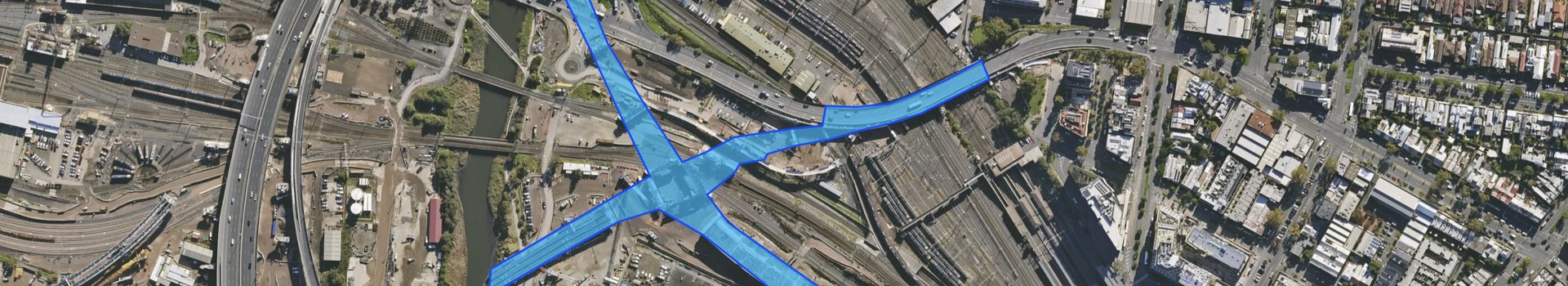
Landchecker provides property professionals with streamlined access to planning information, zoning data, permits, reports, and more through an intuitive map-based platform. By integrating MetroMap’s regularly captured, high-resolution aerial imagery, Landchecker enables users to view properties with clarity, compare historical imagery, and conduct accurate desktop site assessments. This visual intelligence supports better decision-making for architects, developers, valuers, town planners, conveyancers, agents, builders, and property investors.

Stash Property, trusted by investors and buyers’ agents across Australia, consolidates essential property data - from zoning and sales history to suburb heatmaps and tagging tools. Its MetroMap aerial imagery plugin elevates the experience with high-resolution imagery updated regularly. Users can access a timeline view, comparing past and current aerial images, to visually track development trends before visiting sites. This powerful visual context streamlines due diligence, helping users move faster and make smarter investment choices.
UACS specialises in urban analytics & complex systems, leveraging AI & cutting-edge technologies to improve urban planning, infrastructure & environmental management. Partnering with MetroMap, they offer an innovative solution for detecting asbestos-containing materials (ACM). This collaboration has produced the Asbestos Roof Spatial Dataset, a comprehensive tool that pinpoints ACM roofs at a land parcel granularity. The dataset, available for various scales, includes spatial files & detailed property information. These AI models enable ongoing monitoring & forecasting of ACM, supporting regulatory & safety initiatives.
Terrain by Dye & Durham provides environmental and geospatial datasets designed to support compliance, risk assessment, and planning workflows. Professionals across government, legal, and property sectors rely on Terrain for authoritative information that helps them manage environmental risk and regulatory obligations. The integration of MetroMap’s regularly captured, high-resolution aerial imagery enhances Terrain’s datasets by adding visual verification of sites. This helps users see changes over time, validate data against ground reality, and ensure decision-making processes are supported by both trusted datasets and real-world imagery.
Geoscape provides comprehensive geospatial datasets across Australia, including buildings, land parcels, addresses, solar installations, and surface features, updated regularly using aerial and satellite sources. Integrated with MetroMap’s high-resolution, regularly captured aerial imagery, these datasets gain critical real-world visual context. Users can validate data, monitor environmental and urban changes, and confidently analyse land use or development opportunities. This combination empowers planners, developers, and infrastructure professionals with insights grounded in both robust datasets and true-to-life aerial perspectives - helping them make clearer, more reliable decisions.
Anditi provides advanced spatial intelligence and data analytics solutions for environmental monitoring, infrastructure planning, and urban management. By applying AI and big-data techniques to geospatial information, Anditi helps organisations make more sustainable and informed decisions. When combined with MetroMap’s high-resolution, regularly captured aerial imagery, their insights gain added context and accuracy. Users can visually ground their analytics in true-to-life site views - whether assessing vegetation, infrastructure, or land use - making complex environmental and urban challenges easier to interpret and respond to with confidence.
Pylon delivers a solar design platform that streamlines proposals, compliance, and system modelling for installers and consultants. Precision is essential in solar projects, and MetroMap’s regularly captured, high-resolution aerial imagery integrates seamlessly into Pylon’s tools, enabling accurate panel placement, shading analysis, and rooftop mapping. This reduces the need for site visits, accelerates project turnaround times, and ensures proposals are both technically sound and visually compelling. Together, Pylon and MetroMap allow solar professionals to design smarter, faster, and with greater customer confidence.
SolarPlus provides installers with an all-in-one platform for solar design, quoting, compliance, and CRM management. The accuracy of system layouts is central to delivering quality outcomes, and high-resolution aerial imagery is vital in ensuring roof designs align with real-world conditions. By incorporating MetroMap’s regularly captured imagery into workflows, SolarPlus users can achieve reliable panel placement, shading assessments, and compliance checks with reduced site time. This integration supports more efficient design-to-installation processes while ensuring that proposals are precise, professional, and customer-ready.
Sunwiz is a leading provider of solar industry intelligence, delivering data-driven consulting and analytics to inform market strategy, sales, and growth opportunities. While the company’s focus is on insights and performance benchmarking, the addition of MetroMap’s regularly captured, high-resolution aerial imagery provides an extra layer of value. Clear, up-to-date visuals give solar professionals a ground-level perspective to validate datasets, monitor site suitability, and enhance feasibility studies. The combined offering empowers the solar sector to act decisively with both market knowledge and on-the-ground context.
Locatrix is a leading Australian provider of fire safety and emergency evacuation solutions, helping businesses remain compliant with regulations and ensure occupant safety. Its PlanStudio application allows users to mark up buildings and create spatially accurate floor plans and evacuation diagrams. Integrated with MetroMap’s high-resolution, regularly captured aerial imagery, users can geotag buildings, automate and customise egress routes, and measure distances to nearby locations. Combined with PlanSafe and ESP, Locatrix provides a complete solution for building data, training, compliance, and site safety - all enhanced with precise aerial context.
Virtual Estimator provides software for roof and building measurement, cost estimation, and quoting, helping trades and service providers prepare accurate proposals without the need for repeated site visits. Integrated with MetroMap’s high-resolution aerial imagery, the platform allows users to calculate roof areas, assess structures, and choose from regularly captured imagery snapshots to match project timelines. This added clarity not only streamlines estimating processes but also ensures that quotes and proposals are backed by visual evidence - enhancing accuracy and customer trust.
LARKI provides architects, planners and developers with access to detailed 3D surveys and planning data, supporting faster and more accurate project design. By integrating MetroMap’s regularly captured, high-resolution aerial imagery, users gain a clear understanding of site conditions and urban context. LARKI's partnership with MetroMap also extends to selected LiDAR datasets, offering a quick turnaround for 3D Point Cloud data within their platform. This combination of imagery, LiDAR and planning tools streamlines workflows and enhances confidence in early-stage project decisions.
iAM OMNI is a cutting-edge SaaS command-and-control platform that turns complex asset, compliance, and workflow data into clear, actionable insights. By integrating MetroMap’s high-resolution, frequently updated aerial imagery, iAM OMNI transforms maps into operational intelligence, powering asset management, compliance, risk, and community engagement in a single GIS-driven platform. Together, MetroMap & iAM OMNI give councils, utilities, and asset owners a live, accurate, and operational view of their world - helping streamline processes, reduce information silos, and make faster, defensible decisions with confidence.

Canibuild is a digital platform designed for builders and developers to instantly assess properties, manage leads, and streamline project workflows. Its suite of tools covers everything from property searches to quoting and CRM management, helping users cut down manual processes and accelerate decision-making. Within the platform, MetroMap’s high-resolution aerial imagery is directly integrated, enabling users to view sites with clarity, run property assessments, and generate accurate site reports that include static image outputs, all accessible via desktop or mobile.
Aetium is a certification platform that quantifies and validates reductions in CO₂ from actions such as installing solar panels, planting trees, or adopting other carbon-reducing initiatives. Their system issues blockchain-backed credits to track and certify verified carbon savings. As part of this process, MetroMap provides high-resolution aerial imagery at the start of each certification and again every 12 months. This imagery is also used within Aetium’s machine learning models to help verify solar panel installations, orientation, and tree counts - ensuring transparent, accurate, and trusted certification outcomes.
Property Edge by Land Services SA is an interactive platform designed to provide property professionals with accurate, up-to-date information to support assessment, planning, and decision-making. Through a partnership with MetroMap, Property Edge offers high-resolution aerial imagery as a base layer for specific properties. This imagery helps users visualise sites, prepare quotations, and generate PDF proposals with confidence. By combining Property Edge’s property data with MetroMap’s imagery, professionals gain a clearer spatial context to improve project assessments and streamline workflow efficiency.
Accurassi provides energy companies with tools to assess solar potential, manage leads, and streamline project workflows through their Solar Seeker platform. Users can perform solar assessments, generate quotes, and manage CRM processes, all via desktop or mobile. MetroMap’s high-resolution aerial imagery is integrated into the platform, enabling users to visualise properties, validate solar installations, and include static imagery in PDF assessment reports. This combination of data and imagery helps energy companies make more accurate, informed decisions while improving operational efficiency.

uDrew is a platform that guides homeowners, builders, and architects through the building project process, from feasibility to plan submission. The Interactive Planner module allows users to place and adjust proposed structures on their site, test compliance, and measure accurately. MetroMap’s high-resolution aerial imagery is integrated into this module, providing detailed property views when higher zoom or precision is required. Users can generate static imagery for reports, certified drawings, and council forms, helping streamline planning approvals and improve decision-making.

MiClub provides software solutions for community and sporting clubs, helping manage memberships, events, facilities, and communications efficiently. Their MiScore smartphone app supports golf clubs by providing interactive course tools and hole visualisation features. MetroMap’s high-resolution, regularly updated aerial imagery is integrated into MiScore, giving clubs a current view of their course for more accurate visualisation and planning. This imagery enhances the user experience, helps the development team generate up-to-date content, and supports broader efforts to increase adoption and engagement.

Varst provides digital solutions to help property professionals and land developers manage planning, compliance, and assessment workflows more efficiently. Their interactive mapping application includes spatial overlays and visual tools designed for the land development industry. MetroMap’s high-resolution aerial imagery is used as a backdrop within the platform, enhancing spatial context and enabling users to print value-added reports with selected overlays. The imagery helps improve clarity and decision-making for more informed planning and assessment outcomes.

SA1 Pro is an interactive industrial property intelligence platform built to support professionals with accurate, relevant, and current market information. The platform combines extensive property datasets to enable users to monitor market changes, assess new opportunities, and implement informed strategies. MetroMap’s high-resolution aerial imagery is integrated as a base layer within the platform, providing valuable visual context to complement property intelligence. Users access MetroMap imagery directly through SA1 Pro as part of their subscription, making it a seamless and embedded component of the overall service.

Jigsaw Gallery creates premium-quality jigsaw puzzles that celebrate towns, cities, and regions across Australia. The company works with photographers, artists, and illustrators to bring local landscapes to life with engaging, carefully designed puzzles. A selection of their Australian Suburbs puzzles uses MetroMap’s high-resolution aerial imagery, adding precise detail and capturing the unique character of each location. By combining artistic creativity with accurate geographical views, Jigsaw Gallery offers puzzlers a distinctive way to explore Australia.