MetroMap Image Dedicated for ArcGIS is an Esri-compliant service that enables your organisation to access the full value of MetroMap's data.
MetroMap Image Dedicated empowers your teams to harness the full potential of our imagery while optimising management, scalability of large datasets, and cost-effectiveness.
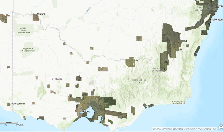
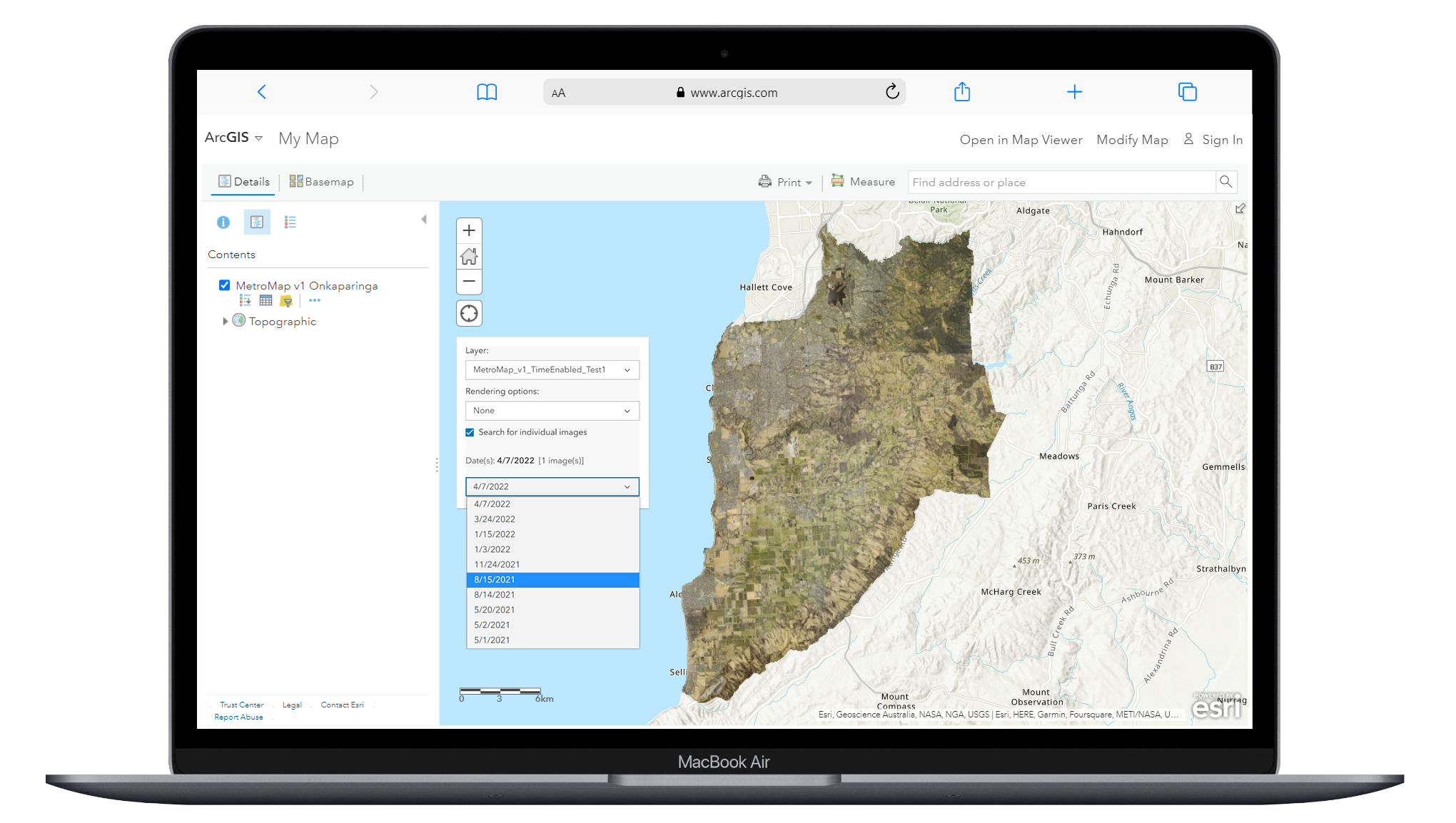
Simply integrate our Australia latest layer and stream it directly to your Esri product suites.
Embed MetroMap high-resolution aerial imagery and satellite imagery as a seamless basemap in your preferred projection.
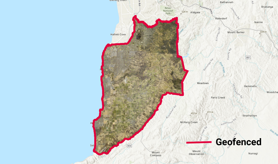
Access a specific area, its historic content, or restrict viewing to internal and external organisations.
Define your area of interest and take advantage of geofenced data and time-enabled features to our national coverage. Provide restricted access to project partners through this option.
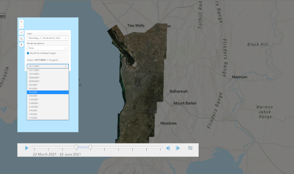
Reduce the complexity of layer management with our date slider and save time.
Seamlessly navigate through MetroMap's national coverage and historical imagery by scrolling through the available dates. View changes more easily and report with less manual handling.
|
Enterprise Plan
|
| This account type can only be paid monthly. | |
| User Access | |
| Users | Custom |
| Data Allowance1 | Custom |
| Web App Access |
|
| WMS/WMTS Access |
|
| MetroMap Image Dedicated for ArcGIS |
|
| View & Compare Imagery | |
| Australia-wide high-resolution aerial imagery (historical and current)2 |
|
| 4-band near-infrared aerial imagery layers |
|
| Swipe tool: compare different imagery layers |
|
| Google Street View, base map layers (satellite & roads)3 |
|
| Measure, Draw and Manage Layers | |
| Measurement, drawing and labelling tools |
|
| Save, export and screenshot drawn-up features in layers |
|
| Import user layers |
|
| High Resolution Image Downloads | |
| Download high-resolution images in multiple file types and projections |
|
| Geoscape Feature Layers and Insights | |
| Property Boundary (Cadastre) & details4 |
|
| Building Footprints and insights for roof, solar panel and swimming pool insights |
|
| Training & Support | |
| Online documentation and in-app tool tips |
|
| Customer Support Team |
|
| Dedicated Account Manager |
|
| Optional training webinar |
|
This account type can only be paid monthly.
|
| User Access | |
| Users | Custom |
| Data Allowance1 | Custom |
| Web App Access |
|
| WMS/WMTS Access |
|
| MetroMap Image Dedicated for ArcGIS |
|
| View & Compare Imagery | |
| Australia-wide high-resolution aerial imagery (historical and current)2 |
|
| 4-band near-infrared aerial imagery layers |
|
| Swipe tool: compare different imagery layers |
|
| Google Street View, base map layers (satellite & roads)3 |
|
| Measure, Draw and Manage Layers | |
| Measurement, drawing and labelling tools |
|
| Save, export and screenshot drawn-up features in layers |
|
| Import user layers |
|
| High Resolution Image Downloads | |
| Download high-resolution images in multiple file types and projections |
|
| Geoscape Feature Layers and Insights | |
| Property Boundary (Cadastre) & details4 |
|
| Building Footprints and insights for roof, solar panel and swimming pool insights |
|
| Training & Support | |
| Online documentation and in-app tool tips |
|
| Customer Support Team |
|
| Dedicated Account Manager |
|
| Optional training webinar |
|