Dr Samuel Holt from Aerometrex met up with Isobel Hume, PhD candidate at the School of Agriculture, Food and Wine (University of Adelaide) and spoke to her about her research on urban agriculture and how she used spatial data to study whether it can be sustainable. Isobel was the first candidate that reached out to MetroMap's Research Data Hub to access some of our data for her research. In addition to aerial imagery supplied directly to her, she was also able to access our LiDAR data captured for a large part of Greater Adelaide through the state government for this study.
Below is a video capturing the full interview as well as excerpts from the same.
Listen to the full interview with Isobel Hume and learn how she answers questions linked to how spatial sciences helped her understand how humans interact with our built ecosystem and the spaces we inhabit, and how we construct them to maintain ecological integrity and have a sustainable future, through urban agriculture.
Can you give us a summary of your PhD and the key research questions you're hoping to address?
"My research is about urban agriculture. I should start by defining what I mean by urban agriculture - "Anything that is growing food or fibre in a city is urban agriculture; it can be on top of buildings, underneath buildings or inside buildings." What I focus on specifically is in-ground vegetable production, which occurs at home on residential land. Most people would just call that their front or backyard veggie garden. The question around my whole thesis is - "Is urban agriculture just this nice idea and something we do as a hobby, or could it be a serious farming system? Can we produce a meaningful amount of food and do that sustainably through urban agriculture?"
Can you tell us about some of the key geospatial data sets that you're using in your project to investigate these questions?
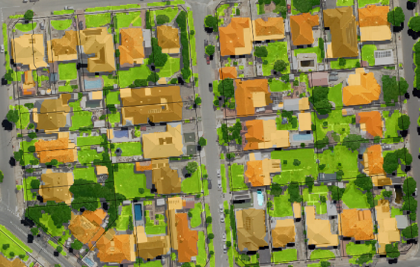
I needed to figure out exactly how much land there was to grow food. To do that, I needed to quantify the amount of residential lawn that there is in Adelaide. I used Aerometrex's spectral imagery to figure out where the vegetation was, and then combine that with point cloud LIDAR data to actually distinguish the spectrally similar but structurally distinct cover types - so lawns and trees, rooftops, pavement, all that kind of stuff.
"We started off focusing on a few key areas but then, as the project grew, we were able to quantify about 500,000 properties across all of Adelaide. So all the way up from Gawler, down to Port Willunga using the Aerometrex data. We covered just about every corner of Adelaide that we could."
What does the diet for an Adelaide household look like in your modelling?
"The recommended vegetable intake, which is the metric that I use to figure out if you could achieve self-sufficiency, is for adults to be eating five servings of veggies per day. I used that as a benchmark for my modelling to try and figure out if we could achieve that level of self-sufficiency. Being realistic, most people actually eat about half of that so I modelled a few different parameters in a few different scenarios to see if we could achieve full dietary self-sufficiency by growing the recommended vegetable intake, as well as maybe partially. The data I used for yield modelling was observational data from urban growers in Adelaide, so it was reflective of what people are actually growing here."
You mentioned you're using some of our imagery and combining it with LIDAR to have a look at how much space is available. What does that tell us about the potential for sustainable agriculture in Adelaide?
A typical property has about 70 square meters of lawn, which is a lot by worldwide standards. It would only take about a third of that lawn space to produce the recommended vegetable intake for the family or the household that's living there."
Do we get an understanding of the spatial variation in people's access to these sorts of things across the city? Is there a variation from the semi-urban areas?
"Unsurprisingly, the Adelaide City Council in the CBD has the lowest self-sufficiency potential rates. I think only about 2% of the properties in the CBD, would be able to achieve self-sufficiency. It got up to about 80% of the properties in areas further out north and further down south. So there was some spatial variability, but perhaps maybe not as much as you would think. It was actually quite random in areas that have more green space and don't have green space. That highlights the importance of using spatial analysis to quantify those things, because maybe it's slightly counter-intuitive, and without analysing it, you might not realise those pockets of vulnerability."
Your second study looks at the built environment from the perspective of how that can contribute to rainwater and harvesting water for agriculture. Does that change the potential for self-sufficiency?
"Once we figured that there was enough space, we also needed to consider how are you going to source the resources to actually produce food, and rainwater was the key thing that I was interested in there. Urban space is very different to commercial rural farms and we have this amazing resource of rooftops in urban spaces. Matching the classification of lawn with the classification of rooftops, we could see that about two-thirds of all the properties in Adelaide could grow enough food to be self-sufficient and capture enough rainwater and store it on site. So we modelled a few different rainfall scenarios to look at dry years, typical years and wet years, as well as storage scenarios. So you need to have a way to store that water from when it falls in winter to when you need it in summer and I was actually able to incorporate the storage part in that spatial analysis as well. So it does reduce the self-sufficiency potential for some people."
Do you see how we're going to shift perspectives on converting space to urban agriculture?
"It’s unfortunate that times of crisis spur interest in urban agriculture. Unfortunately, at the moment, we probably are still feeling the effects of the pandemic. The most recent hunger reports are showing that more people in Australia than ever are struggling to be able to afford the varied diets that they used to, especially those with vegetables and highly nutritious foods. So I would hope that people would turn to urban farming for a whole variety of reasons, and by promoting sustainable outcomes, community leaders and groups can push that, and share knowledge through community gardens. We've had some really good communications with the SA Urban Food Network which hosts information nights and gets people together to share stories of local food. Some councils have also been very interested in this research.”
What are the big risks to the potential for this self-sufficiency? Is it the urban infill, changing climate, or both?
“One of the parameters that I looked at was when these houses were built. We found that houses that are built more recently are actually less likely to be able to achieve self-sufficiency. That is indicating that we're perhaps trending the wrong way. I think there's definitely the opportunity with careful planning to have enough space for urban agriculture and meet those sustainability targets that come through with urban infill.”