As our Australian cities expand and evolve, it's essential to keep a close eye on the changes happening in our urban environments. Local and state governments are increasingly turning to advanced technologies, such as aerial imagery and Artificial Intelligence (AI), to analyse these transformations and make informed decisions for sustainable development of our cities. As the frequency of aerial imagery capture increases, access to the latest information and more detailed trends can be accessed.
In this article, we'll explore how imagery-derived information and insights are being used to monitor tree canopy changes and solar adoption in new developments, shedding light on the dynamic nature of our cities.
The increasing rate of urbanization comes with a significant environmental concern – the loss of tree canopy. Trees not only enhance the aesthetics of our neighbourhoods but also provide numerous ecological benefits, including air purification, temperature regulation, and habitat for wildlife. Unfortunately, rapid urban development often leads to the removal of trees, impacting the overall tree canopy cover.
Local councils and environmental organisations are addressing this concern by harnessing the power of AI and aerial imagery analysis. With the help of AI algorithms, these organisations can extract information from high-resolution aerial imagery to identify tree canopy loss associated with new developments. By comparing current imagery to historical data, they can track changes over time and pinpoint areas where tree canopy cover has been significantly reduced, especially on private land.
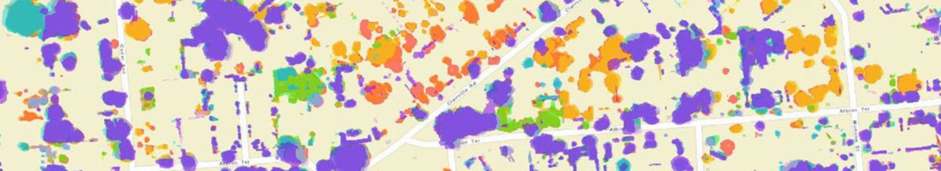
This image shows the change in tree canopy cover over part of an LGA for the past 8 years. The purple layer represents the tree canopy cover in Jan 2022, and highlights the reduction in canopy cover at points in time right back to the red layer in Feb 2015.
Change analysis using AI doesn't stop at identifying tree canopy loss. It also extends to gaining insights into the broader trends shaping our cities. Urban environments are constantly evolving, with new buildings, roads, and infrastructure projects sprouting up. AI allows us to monitor these changes efficiently and extract valuable information.
For instance, local councils can use AI to track the growth of residential and commercial buildings and how they are closely intertwined with tree canopy loss. This information can inform decisions related to zoning and infrastructure development and put in place policies and initiatives to reduce tree canopy loss on vacant lands, helping councils adapt to the evolving needs of their communities.
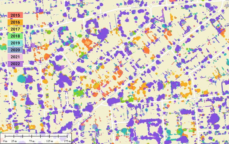
This image shows canopy loss in the Campbelltown LGA between 2019 and 2023. The red areas show the canopy loss that is replaced by the increased trend of building intensity in new development areas shown in purple.
In recent years, there has been a growing interest in renewable energy sources, with solar power emerging as a key player in sustainable urban development. Many local councils are encouraging the adoption of solar panels to reduce carbon footprints and promote clean energy. AI plays a pivotal role in tracking this trend and provide business units with quantitative information around adoption of solar energy.
By analysing aerial imagery, AI algorithms can accurately detect solar panels on rooftops and open spaces. This allows local councils to assess the extent of solar adoption in their jurisdictions and identify areas with high or low solar panel density. Such data can be used to develop incentive programs, promote renewable energy installations, and measure progress towards sustainability goals.
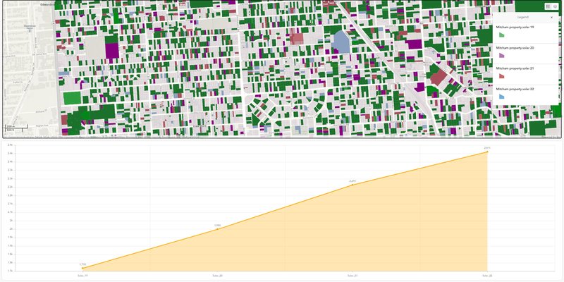
This graph shows the increasing trend of solar panel installation in Mitcham LGA between 2019 and 2022, the line chart represents the solar panel area extent detected in m2.
Analysing change in our urban environments through AI has become increasingly important for local councils and city planners. Change analysis provides a wealth of information, from identifying environmental concerns like tree canopy loss to tracking urban development trends. Here are a few examples of how local councils use change analysis:
Environmental Conservation: Identifying areas with significant tree canopy loss helps councils implement tree planting initiatives to mitigate environmental impacts.
Infrastructure Planning: By monitoring changes in infrastructure, councils can prioritize road maintenance and optimize public transportation routes. Changes also informs councils about population growth and shifting demographics.
Land Use Planning: Local councils can make informed decisions about land use, zoning, and urban development based on change analysis data. They can ensure that new developments align with zoning regulations and land-use policies.
Sustainability Initiatives: Tracking solar adoption helps councils assess progress toward sustainability goals and implement policies to further encourage renewable energy.
Compliance: Tracking building changes at the property level such as addition of granny flats, house extension, veranda, swimming pools allow local councils and regulatory authorities to closely monitor alterations to structures and land use.
Property Tax Assessment: Accurate property tax assessments are essential for funding local services. Aerial imagery analysis assists councils in evaluating changes in property values, ensuring that tax revenues remain fair and sufficient to support community needs.
As our cities evolve, change analysis using AI has become an indispensable tool for local councils, urban planners, environmental and sustainability services, and compliance services. Technology in this case enable decision-makers to access quantitative and accurate spatial information which are not possible to be extracted manually.
Whether it's mitigating tree canopy loss, understanding dynamic urban trends, promoting sustainable practices like solar adoption, or uphold regulations, AI-powered analysis empowers decision-makers to create more resilient and environmentally friendly communities.